Showing posts with label Archaeology. Show all posts

Tuesday, February 23, 2016

Hadda: Greek-Buddhist Archeological Site (1st c. AD)

**************************

Click Here to View the Main Index

**************************

"Haḍḍa (Pashto: هډه‎) is a Greco-Buddhist archeological site located in the ancient region of Gandhara, near the Khyber Pass, ten kilometers south of the city of Jalalabad in eastern Afghanistan."

Click on the map to enlarge.

"Some 23,000 Greco-Buddhist sculptures, both clay and plaster, were excavated in Haḍḍa during the 1930s and the 1970s. The findings combine elements of Buddhism and Hellenism in an almost perfect Hellenistic style......Although the style of the artifacts is typical of the late Hellenistic 2nd or 1st century BC, the Haḍḍa sculptures are usually dated (although with some uncertainty), to the 1st century AD or later (i.e. one or two centuries afterward). This discrepancy might be explained by a preservation of late Hellenistic styles for a few centuries in this part of the world. However it is possible that the artifacts actually were produced in the late Hellenistic period......Given the antiquity of these sculptures and a technical refinement indicative of artists fully conversant with all the aspects of Greek sculpture, it has been suggested that Greek communities were directly involved in these realizations, and that "the area might be the cradle of incipient Buddhist sculpture in Indo-Greek style"..... John Boardman, The Diffusion of Classical Art in Antiquity

"Hadda is 10 km south of the Kabul River...... (Kābol Rōd, also called Daryā-ye Kābol), in eastern Afghanistan and tributary of the Indus....its drainage area takes up large proportions of eastern Afghanistan with the nine provinces of Nangarhār, Kunar, Laḡmān, Lōgar, Kabul, Kāpisā, Parvān, Panjšēr, and Bāmiān.....the East flowing Kabul River, which in times past, was known as the Sita, or White River.... In the year 1900 the Russian mystic George Ivanovitch Gurdjieff traveled by raft down part of this river, as part of an expedition led by Prof. Kozlov in search of the ruins of ancient Shambhala.".......http://www.dharmafellowship.org/library/essays/uddiyana.htm

Sir Alexander Burnes Map (1834)...Click on the map to enlarge.

"Captain Sir Alexander Burnes, FRS (16 May 1805 – 2 November 1841) was a Scottish traveller and explorer....His travels continued through Afghanistan across the Hindu Kush to Bukhara (the maps and narrative which he published in England in 1834)"

"Musée Guimet:: Afghanistan: Hadda......The Buddhist monastery complex at Hadda in Eastern Afghanistan, not far from Kandahar, yielded a rich trove of sculpture and painting during the French excavations of the late 1930s......Hadda, Monastery of Bagh-Gai. 3rd-4th c. AD.....Barthoux expedition 1927-28.....https://depts.washington.edu/silkroad/museums/mg/hadda.html"

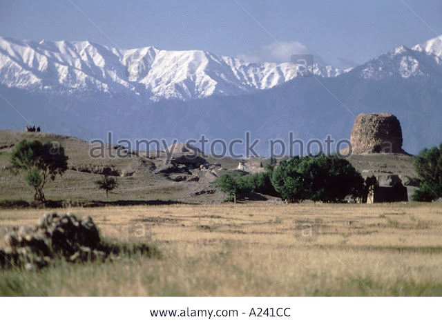
The Buddhist stupa of Tapa Kalan, Hadda (near Jalalabad in the Kabul River valley

"Hadda, a small town 15 km south of Jalalabad (Eastern Afghanistan), owes its fame to the number and beauty of the remains of its Buddhist stūpas, shrines and monasteries scattered over an area of 15 km2 around the urban settlement......Throughout the period of Buddhism’s great flourishing, from the Kushans (1st–3rd century AD) into the 7th century AD, Hadda was a popular pilgrimage destination where, according to the accounts of famous Chinese pilgrims such as Faxian and Xuanzang, various relics of the Buddha’s body and belongings were preserved, each of them enshrined in a stūpa: a bone of the Buddha’s skull and uṣṇīṣa (cranial protuberance), an eyeball, the monastic robe and the ascetic staff....Exploration of the site began in 1834 with Charles Masson, who discovered Graeco-Bactrian, Indo-Scythian, Hunnic, Roman and Byzantine coins inside 14 stūpas in different sacred areas. The most important of these, Tapa Kalan, also yielded fragments of stone and stucco sculptures. Further minor investigations followed, until J. Barthoux of the Délégation Archéologique Française en Afghanistan carried out extensive excavations on various sites from 1926 to 1929.....Their astonishing beauty and liveliness, originally enhanced by a vibrant color, which has only minimally been preserved, and especially their Hellenistic touch aroused great interest......Between the mid-1960s and the end of the 1970s other sites were excavated by Afghan and Japanese teams. Tapa Shotor, one of the most interesting sites to be excavated during this period, revealed shrines housing cultic images and scenes characterized by the theatrical arrangement of the sculptures and their lively background (2nd–5th century AD) as well as an underground room, probably restricted to the monks’ meditation practices, as suggested by the painted decoration (5th–6th century AD) dedicated to the theme of meditation on death......In the course of the Afghan civil war, the majority of known archaeological sites was destroyed by the Taliban."...http://pro.geo.univie.ac.at/projects/khm/showcases/story233?language=en .

"In 1834, Charles Masson’s excavations in the region of Kabul and Jalalabad included a series of Buddhist ‘Topes’, i.e. stupas (sacred domed structures symbolizing the Buddha). Tope Kelan (Stupa 10) on the outskirts of Hadda, a village south of Jalalabad in south-eastern Afghanistan..... The relic deposit contained more than 200 coins buried along with a variety of over 100 objects including silver rings, gilded bronze, silver and gold reliquaries, glass and semi-precious beads and brass pins including a unique cockerel-headed example. These were buried as part of a Buddhist ritual aimed at earning merit in the afterlife."....http://blog.britishmuseum.org/category/collection/money-gallery/

"The Tope Kelan deposit contains five series of coins, Byzantine gold solidi, Sasanian silver coins, Alchon Hun silver coins, Kidarite Hun gold and silver coins, and a gold coin from Kashmir, all minted before AD 480. The hoard is important evidence of the Silk Route trade network that crisscrossed Europe, Central Asia to China and India in the first millennium AD. The Tope Kelan hoard is thus a testimony to the multiculturalism of ancient Afghanistan with its links to the Indian sub-continent, Iran and China.".......http://blog.britishmuseum.org/category/collection/money-gallery/

"The Buddhist Shrine Complex at Hadda. A Greco-Buddhist archeological site located in the ancient area of Gandhara, six miles south of the city of Jalalabad in eastern Afghanistan, Hadda was one of the largest Buddhist temple and pilgrimmage complexes in the world during the 1st through 3rd centuries AD.......A key location on the 2,000-mile path that pilgrims followed in the transmission of Buddhism from India to China, Hadda was an active center for manuscript translation and duplication as well as sculpture. ....More than 23,000 Greco-Buddhist sculptures made of clay or plaster, architectural decorations plus heads and figures depicting men, women, children, assorted demons, as well as the elderly, with every conceivable mode of expression and dress, every rank and status, every facial type from all corners of the known world — more faces than one would need to re-create an entire Buddhist city — were excavated from Hadda in a series of archaeological excavations during the 1930s and the 1970s. .....Sculptures from Hadda combine elements of Buddhism and Hellenism, in an almost perfect uniquely identifiable Hellenistic style. Although the style itself is suggested by experts to date from the late Hellenistic 2nd or 1st century BC, the sculptures from Hadda are usually dated, tentatively, to the 1st century AD or later. .....Given the early date, superb quality, technical refinement, variety and stupendous quantity of sculptures, Hadda must have been a "factory town" where Greek or Greek-trained artists familiar with all the aspects of Hellenistic sculpture, lived and worked in, what scholar John Boardman described as "the cradle of incipient Buddhist sculpture in Indo-Greek style." .....The transferance of Greek heros to Buddhism (e.g., Herakles being the inspiration and model for the Buddhist Bodhissatva) is fully on display at Hadda. ....A sculptural group excavated at the Hadda temple known as Tapa-i-Shotor, for example, represents a Buddha flanked by a perfectly Hellenistic figure of Tyche holding her cornucopia and Herakles holding not his usual club, but the thunderbolt associated with the Boddhisatva fiture Vajrapani."...http://www.cemml.colostate.edu/cultural/09476/afgh02-08enl.html

"Hercules and the Buddha....In Gandharan art, the Buddha is often shown under the protection of the Greek god Herakles, standing with his club (and later a diamond rod) resting over his arm...Via the Greco-Buddhist culture, Heraclean symbolism was transmitted to the far east.....Heracles was perhaps the most popular hero god of the Greeks. In the Greek colonies in Bactria and India, the club wielding lion killer, Heracles became Vajrapani a protector of Buddha. Still recognizable as a bearded Greek with a club....which became the diamond thunderbolt).... "

"In addition to sculpture, Hadda contained some of the the oldest surviving Buddhist manuscripts in the world, which are perhaps the oldest surviving Indian manuscripts of any kind,the long-lost canon of the Sarvastivadin Sect that dominated Gandhara and was instrumental in Buddhism's spread from India to China. ....Probably dating from around the 1st century AD, looted from Hadda during the 1990s and smuggled to Pakistan, these Buddhist manuscripts were written on birch bark in the Gandhari language. Discovered in a clay pot bearing an inscription in the same language eventually passed to the British Library in London and the University of Washington in Seattle. The legal ownership of these priceless manuscripts remains in dispute. ....More than 1000 of the vast assemblage of sculptures found at Hadda during the 1930s and 1970s were secured at the Kabul Museum and the Musée Guimet in Paris.".....http://www.cemml.colostate.edu/cultural/09476/afgh02-08enl.html

http://c8.alamy.com/comp/A241CC/hadda-monuments-at-darunta-on-the-road-to-hadda-afghanistan-A241CC.jpg

**************************

Email....okarresearch@gmail.com

February 2016

**************************

Thursday, December 17, 2015

The Kingdom of Zhun and Takzig/Tibetan Bon

**************************

Click Here to View the Main Index

**************************

"The shrine of Zun in Zamindawar, which was believed to be located about three miles south of Musa Qala in today's Helmand Province of Afghanistan.......Scholars have noted several similarities between the religion of Zhun and the pre-Buddhist, religion of Tibet ......"

"CULT of ZHUN........Before Islam reached Afghanistan the population followed several religious traditions, some imported (including Zoroastrianism, Hinduism, and Buddhism), others indigenous. Of the indigenous religions we know most about the cult of Zhun (Zun), because it was described in some detail by a Chinese Buddhist pilgrim, Xuan Zang, who visited Afghanistan shortly before the Arab invasion (BOSWORTH 1984, 4-7). Based on the worship of a golden idol with ruby eyes, the cult of Zhun (widespread throughout Zamindawar and Zabulistan) survived for two centuries after the arrival of Islam. The idol was housed in a temple, in front of which stood the vertebra of a giant reptile, locally believed to be that of a dragon. The priests of Zhun seem to have possessed shaman-like abilities, for Xuan Zang describes them as having powers to control demons and other supernatural forces and being able to both heal and harm people (BoswoRTH 1984, 6).

"Zunbils ruled Zamindawar before Islamization of the area. The title Zunbil can be traced back to the Middle-Persian original Zūn-dātbar, 'Zun the Justice-giver'. The geographical name Zamindawar would also reflect this, from Middle-Persian 'Zamin-i dātbar' (Land of the Justice-giver).....Zamindawar is a historical district of Afghanistan, situated on the right bank of the Helmand River to the northwest of Kandahar.... André Wink: In southern and eastern Afghanistan, the regions of Zamindawar and Zabulistan or Zabul (Jabala, Kapisha, Kia pi shi) and Kabul, the Arabs were effectively opposed for more than two centuries, from 643 to 870 AD, by the indigenous rulers the Zunbils and the related Kabul-Shahs of the dynasty which became known as the Buddhist-Shahi...... The Zunbil kings worshipped a sun god by the name of Zun from which they derived their name. For example, André Wink writes that "the cult of Zun was primarily 'Hindu', not Buddhist or Zoroastrian... the shrine of Zun in Zamindawar, which was believed to be located about three miles south of Musa Qala in today's Helmand Province of Afghanistan."

"TIBETAN BON.........Scholars have noted several similarities between the religion of Zhun, the shamanic religions of Central Asia, and the pre-Buddhist, dragon-god religion of Tibet (Bosworth 1984, 7)......Following Afghanistan's conversion to Islam during the seventh century AD., many of the pre-existing shamanistic beliefs and practices were incorporated into the framework of Muslim cosmology. The ecstatic techniques associated with Islam's mystical Sufi tradition must have lent themselves particularly well to the assimilation of indigenous shamanistic practices."

Click on the map to enlarge

"The Bon religion of the royal period (seventh to ninth centuries) is said to have come from Tazig (stag gzig, Tajik/Iran) via Zhang Zhung, and Zhang Zhung is the probable source of other early components of Tibetan civilization. A pre-Buddhist shamanistic religion prevalent in early Tibet, Bon developed just west of Mount Kailash in Guge (gu ge), the capital of the ancient kingdom of Zhang Zhung. Like the Buddhists who came centuries after him, Tonpa Shenrab Miwoche (ston pa gshen rab mi bo che) combined the various native mystical cults under his own to fashion Bon, or Bön. He settled in Zhang Zhung, presently known as western Tibet's Guge region. Centered on the Tibetan Plateau, the tale of the kingdom of the Bon people is of profound importance, for it was from the Bon kingdom of Zhang Zhung that the myth of Shambhala arose. Shambhala, named Olmo Lung Ring ('ol-mo lung-rings), was considered to be one of the great centers of the Zhang Zhung culture of central Tibet. These people settled in Tibet and practiced some form of ritual Bon culture, which must have evolved from Hinduism and Zoroastrianism."....http://www.yungdrung.org/doc/Compilation_History_Zhang_Zhung.pdf

"Musa Qala ('Fortress of Moses') is a town and the district center of Musa Qala District in Helmand Province, Afghanistan. It sits at 32.4433°N 64.7444°E and at 1043 meters altitude in the valley of Musa Qala River in the central western part of the district. It is in a desolate area, populated by native Pashtun tribes......

"Sangin is a town in the valley of the Helmand River at 888 m altitude, 95 km to the north-east of Lashkar Gah. Sangin is notorious as one of the central locations of the opium trade in the south of the country, and is also a town that has traditionally supported the Taliban. It was described by British newspaper The Guardian as "the deadliest area in Afghanistan".

Click on the map to enlarge

"Lashkar Gah historically also called Bost (Persian: بُسْت‎‎), is the capital of Helmand Province. It is located in Lashkar Gah district, and situated between the Helmand and Arghandab rivers. The city is linked by major roads with Kandahar to the east, Zaranj to the west, and Herat to the north-west. .....Lashkar Gah was part of the Saffarids in the 9th century. It grew up a thousand years ago as a riverside barracks town for soldiers accompanying the Ghaznavid nobility to their grand winter capital of Bost. The ruins of the Ghaznavid mansions (Qala-e-Bost )......still stand along the Helmand River; the city of Bost and its outlying communities were sacked in successive centuries by the Ghorids, Mongols, and Timurids.

"The great fortress of Bost, Qala-e-Bost, remains an impressive ruin. It is located at 31° 30’ 02″ N, 64° 21’ 24″ E near the convergence of the Helmand and Arghandab Rivers, a half hour's drive south of Lashkar Gah. Qala-e-Bost is famous for its decorative arch.....As of April 2008, it was possible to descend into an ancient shaft about 20 feet across and 200 feet deep, with a series of dark side rooms and a spiral staircase leading to the bottom. In 2006 construction began on a cobblestone road to lead from the south of Lashkar Gah to the Qala-e-Bost Arch (known to readers of James A. Michener's Caravans as Qala Bist.)"

Click on the map to enlarge

"Zhang Zhung (transcribed Zhang Zhung, Shang Shung, Zan Zun or Tibetan Pinyin Xang Xung)was an ancient culture and kingdom of western and northwestern Tibet, which pre-dates the culture of Tibetan Buddhism in Tibet. Zhangzhung culture is associated with the Bon religion, which in turn, has influenced the philosophies and practices of Tibetan Buddhism....The Zhang Zhung culture was centered around sacred Mount Kailash and extended west to Sarmatians..... the area of Shang Shung was not historically a part of Tibet and was a distinctly foreign territory to the Tibetans.....about 950 AD, the Hindu King of Kabul had a statue of Vişņu, of the Kashmiri type (with three heads), which he claimed had been given him by the king of the Bhota (Tibetans) who, in turn had obtained it from Kailāśa.....Zhang Zhung flourished until around 700 AD, when deteriorating climate and cultural and religious changes in Tibet combined in its demise."

"The Sarmatians (Latin: Sarmatæ or Sauromatæ, Greek: Σαρμάται, Σαυρομάται) were a large confederation of Iranian people during classical antiquity, flourishing from about the 5th century BC to the 4th century AD. They spoke Scythian, an Indo-European language from the Eastern Iranian family.......Originating in Central Asia, the Sarmatians started their westward migration around the 6th century BC, coming to dominate the closely related Scythians by the 2nd century BC. The Sarmatians differed from the Scythians in their veneration of the god of fire rather than god of nature, and women's prominent role in warfare......Like the Scythians, Sarmatians were of a Caucasoid appearance....."

"The Aryan terms for deity are borrowed from fire and light. For example, 'deva' is from the root 'div' which means 'to shine'. In old Sanskrit, 'Athar' is 'fire'."..(James: 1963...pg 79)...

"According to the Bönpo tradition, although Yungdrung Bön is eternal and without an ultimate beginning in time, it originated in the present kalpa or cycle of existence in the country of Ölmo Lungring where Tönpa Shenrab descended from the celestial spheres and took up incarnation among human beings as an Iranian prince. The mysterious land of Ölmo Lungring (`ol-mo lung-rings) or Ölmoling (`ol-mo`i gling) is said to be part of a larger geographical region to the northwest of Tibet called Tazig (stag-gzig, var. rtag-gzigs), which scholars identify with Iran or, more properly, Central Asia where in ancient times Iranian languages such as Avestan and later Sogdian were spoken.".....http://bonchildren.tonkoblako-9.net/en/jewel2/03.tan

Click on the map to enlarge

"Zunbil, also written as Zhunbil, was a dynasty south of the Hindu Kush in present southern Afghanistan region. They ruled from the early 7th century until the Islamic conquest of Afghanistan in 870 AD. The Zunbils are believed to be an offspring of the southern-Hephthalite rulers of Zabulistan. The dynasty was related to the Kabul Shahis of the northeast in Kabul. "It follows from Huei-ch'ao's report that Barhatakin had two sons: one who ruled from after him in Kapisa-Gandhara and another who became king of Zabul......The Zunbils worshiped the sun, which they named Zun (pronounced "zoon") from which they derived their name. Their territory included between what is now the city of Zaranj in southwestern Afghanistan and Kabulistan in the northeast, with Zamindawar and Ghazni serving as their capitals. The title Zunbil can be traced back to the Middle-Persian original Zūn-dātbar, 'Zun the Justice-giver'. The geographical name Zamindawar would also reflect this, from Middle Persian 'Zamin-i dātbar' (Land of the Justice-giver).... The shrine of Zoon (sun god) was located about three miles south of Musa Qala in Helmand, which may still be traced today. Some believe that the Sunagir temple mentioned by the famous Chinese traveler Xuanzang in 640 AD pertains to this exact house of worship.".....

"It was during the governorship in Khorasan of ʿAbdallāh b. ʿĀmer for the caliph ʿOṯmān that the Arabs first appeared in Sistān, when in 652 AD Zarang surrendered peacefully, although Bost resisted fiercely. From the base of Zarang, raids were launched eastwards into Arachosia/Roḵḵaj and Zamindāvar against the local rulers, the Zunbils, and as far as Kabul, against the Kābolšāhs. A process of gradual Islamization must have begun in Sistān, although Zoroastrianism and Christianity long persisted there, certainly into the 11th century, with the Zoroastrian fire-temple at Karkuya (Karkuy) to the north of Zarang long maintained."......http://www.iranicaonline.org/articles/sistan-ii-islamic-period

Iran By Patricia L. Baker, Hilary Smith, Maria Oleynik

"Mount Khwaja is also an important archaeological site: On the southern promontory of the eastern slope, the ruins of a citadel complex - known as the Ghagha-Shahr - with its remains of a fire temple attest to the importance of the island in pre-Islamic Iran. According to Zoroastrian legend, Lake Hamun is the keeper of Zoroaster's seed. In Zoroastrian eschatology, when the final renovation of the world is near, maidens will enter the lake and then give birth to the saoshyans, the saviours of humankind.... the ruins are called Qal'a-e Kafaran "Fort of Infidels" or Qal'a-e Sam "Fort of Sam," the grandfather of the mythical Rostam".....

**************************

Email....okarresearch@gmail.com

December 2015

John Hopkins....Northern New Mexico

**************************

Saturday, November 28, 2015

The Deity Oxus & Ancient Bactrian Polytheism

**************************

Click Here to View the Main Index

**************************

"There are many gods....They are always present everywhere.....we prefer to use the term Naturalism rather than Polytheism."

"The single most important element that dominates the landscape of ancient Bactria is the river Amu Darya, the ancient Oxus, and its many tributaries. Bactria without Oxus is almost unimaginable.....yet most research has been confined to the study of the "major" religions (Buddhism, Zoroastrianism and/or Islam)...... Despite that, the local Bactrian polytheistic pantheon presents an amazing richness and forms a fascinating field of study, yet acknowledged by not many modern scholars."......THE LOCAL RIVER GOD OXUS-WAKHSH IN PRE-ISLAMIC BACTRIA.....http://www.iranianstudies.com/content/local-river-god-oxus-wakhsh-pre-islamic-bactria

"It is a river deity or aquatic deity for which we know two things for certain: that in the Hellenistic period a whole temple was dedicated to this god and that much later, in the seventh and eighth century CE, local people took its worship seriously by taking oaths on its name during their legal and economic transactions.".....http://www.iranianstudies.com

Valley of Takhti Sangin

Takht-i Sangin....The ancient town of Takht-i Sangin is located near the confluence of the Vakhsh and Panj rivers, the source of the Amu Darya, in southern Tajikistan.....The Greco-Bactrian temple site of Takht-i Sangin is believed by many to be the source of the Oxus Treasure that now resides in the Victoria and Albert Museum and British Museum. Part of greater Transoxiana and built in the 3rd Century BC, the site consists of a well-fortified citadel containing the so-called "Temple of Oxus".....Holt, F.L. (1989), Alexander the Great and Bactria: The Formation of a Greek Frontier in Central Asia: 2nd Edition, Brill Archive.

"OXYARTES......Hellenized form of the Old Persian male name Vaxšuvarda (also seen spelled as Vakhshuvarda), which was derived from older Persian Vaxšuvadarva......part of the name referring to Vakhsh, the Aramaic counterpart of the Greek river god Oksos or Oxos (known as Oxus in Latin).... Oxyartes would then be a Greek transliteration of the original Aramaic name......if one looks up the Oxus river (nowadays called Amu Darya) from which the river god derived its name (or vice versa).....Vakhsh is said to be ultimately derived from Sanskrit Vaksu. A known bearer of this name was the father of Roxana, the Bactrian wife of Alexander the Great (4th century BC)."......."Kingship in Hellenistic Bactria" by Gillian Catherine Ramsey.....http://www.behindthename.com/name/oxyartes/submitted

"In modern Takht-i Sangin, on the Uzbekistan-Afghanistan borders, along the river Amu Darya (Gr. Oxus, Bact. Wakhsh), a large temple complex has been excavated by Russian archaeologists, which bears little resemblance to typical ancient Greek religious architecture. However, this building has provided us with significant evidence for the cult of the local river god Oxus through Greek inscriptions from the time of the Greco-Bactrian kingdom. A famous stone altar base with a standing Marsyas on top, fragments from a stone perirrhanterion on the temple’s entrance and a bronze caldron preserve dedicatory inscriptions mentioning god Oxus. All names of the devotees are Iranian, but the “epigraphic habit”, god Marsyas, the caldron and the perirhanterion are a clear reference to a Greek understanding of the ritual and the cult.".....https://hellenisticmonarchies2015.wordpress.com/day-2/spyridon-loumakis/

"The popularity of the local cult of Oxus can be seen in the amount of examples of Oxus-based theophoric names found in Aramaic documents from Bactria, dated from 353 to 324 BC, possibly from the archive of the satrap of Bactria, and in the epigraphic data from the Hellenistic city of Aï Khanoum in Bactria (before the mid second c. BC). In addition, we know from ancient Greek authors that Oxy-atres was the name of Darius III’s brother (Arrian, Anabasis 7.4; Strabo, Geography 12.3.10), that Oxy-dates was a high royal Persian, imprisoned by Darius III, and later appointed satrap of Media by Alexander III (Arrian, Anabasis 3.20; 4.18) and that Oxy-artes was one of the four powerful noblemen of Bactria who resisted the advance of Alexander III’s army (Arrian, Anabasis 3.28; 4.18-21; 6,.5; 7.4; 7.6; Diod. Sic., Historical Library 2.6.2)."....Spyridon Loumakis (Concordia University): “Oxus-Wakhsh: A Local River God in Hellenistic Bactria”......https://hellenisticmonarchies2015.wordpress.com

".... this unique temple, which mixes Hellenistic and local Iranian religious traditions in many levels (sacred setting, ritual, cult) was extremely significant for the eastern most border of the Hellenistic world in central Asia, based on three arguments: (a) on the temple’s variety and richness of offerings (more than eight thousand excavated objects of alabaster, clay, terra cotta, bone, ivory, semiprecious stones, glass, textiles, iron, bronze, silver and gold), (b) on its monumental proportions, which manifest the concentration of great political and economic power, and (c) on the abundance of arms dedicated to the temple, probably the biggest assemblage in the entire Central Asia, with different types of offensive and defensive armour, from Hellenistic, Middle Eastern and Sarmatian-Scythian origins.".....Spyridon Loumakis......https://hellenisticmonarchies2015.wordpress.com

"In the extremely beautiful spot where the Vakhsh and Pyanj rivers flow together and give birth to the Amu Darya lie the ruins of the Takhti Sangin temple, a Zoroastrian temple of the Achaemenid Persian period.....During the silk-road period it was a center where merchants visited by land and river. Here, it is believed, the Oxus Treasure pieces were found in 1877; beautiful objects of incredible elegance and beauty..... the Takhti Sangin temple has various legends. Signs of different religions have been found, indicating that the temple existed as a strategic point of trade between the east and west....it takes two days to explore Takhti Sangin and other small castles along Amu Darya river and Tigrovaya Balka Nature Reserve.... unfortunately, the story of the temple is different, its location right in the border with Afghanistan means that few can currently get permission to visit.."....by Bahodur Sheraliev.....

"...northeastern Bactria (that is, the Hindu Kush region) was known as Kafiristan ("Land of the Infidels" in Persian) because of the people's fierce resistance to Islam and unique polytheism (different than Hinduism).....

"The Oxus region is home to archaeological relics of grand civilisations, most notably of ancient Bactria, but also of Chorasmia, Sogdiana, Margiana, and Hyrcania. However, most of these ruined sites enjoy far less fame, and are far less well-studied, than comparable relics in other parts of the world....most of the ruins have been neglected by the modern world – largely due to the region's turbulent history.....

Ayaz Kala of Khwarezm (Chorasmia), today desert but in ancient times green and lush

"The Oxus is the largest river (by water volume) in Central Asia. Due to various geographical factors, it's also changed its course more times (and more dramatically) than any other river in the region, and perhaps in the world.......The source of the Oxus is the Wakhan river, which begins at Baza'i Gonbad at the eastern end of Afghanistan's remote Wakhan Corridor......The Oxus proper begins where the Panj and Vakhsh rivers meet, on the Afghanistan-Tajikistan border...... the land that was the region's showpiece in the antiquity period: Bactria. The Bactrian heartland can be found south of Sogdiana, separated from it by the (relatively speaking) humble Chul'bair mountain range. Bactria occupies a prime position along the Oxus river: that is, it's the first section lying downstream of overly-rugged terrain; and it's upstream enough that it remains quite fertile to this day, although it's significantly less fertile than is was millennia ago...... surprisingly little is known about the details of ancient Bactria today. ....The capital of Bactria was the grand city of Bactra, the location of which is generally accepted to be a circular plateau of ruins touching the northern edge of the modern-day city of Balkh. These lie within the delta of the modern-day Balkh river (once known as the Bactrus river), about 70km south of where the Oxus presently flows. In antiquity, the Bactrus delta reached the Oxus and fed into it; but the modern-day Balkh delta (like so many other deltas mentioned in this article) fizzles out in the sand......Balkh is believed to have been inhabited since at least the 27th century BC.....due to decades of military conflict in the area, access continues to be highly restricted, for security reasons.".....Forgotten realms of the Oxus region...http://greenash.net.au/

"....in Upper Bactria is the archaeological site of Takhti Sangin. This ancient ruin can be found on the Tajik side of the border; and since it's located at almost the exact spot where the Panj and Vakhsh rivers meet to become the Oxus.....The principal structure at Takhti Sangin was a large Zoroastrian fire temple, which in its heyday boasted a pair of constantly-burning torches at its main entrance. Most of the remains at the site date back to the 3rd century BC, when it became an important centre in the Greco-Bactrian kingdom (and when it was partially converted into a centre of Hellenistic worship); but the original temple is at least several centuries older than this, as attested to by various Achaemenid Persian-era relics.....Takhti Sangin is also the place where the famous "Oxus treasure" was discovered in the British colonial era (most of the treasure can be found on display at the British Museum to this day)..... Takhti Sangin has been studied only sporadically by modern archaeologists.....Forgotten realms of the Oxus region...http://greenash.net.au/

"In Dancing With the Sacred, Karl Peters proposes that the sacred is the dance of life (a form of god). He develops an understandable naturalistic theism in which the Universe is not governed by a personal supernatural God. This determination is not atheistic, for the concept of the divine is preserved in a system of non-personal processes within the natural world. Nature produces variations that generate new aspects of existence that are creative but without design.".....Dancing With the Sacred: Evolution, Ecology, and God - Trinity Press International, 2002,

"The Oxus River, identified as the world river that descends from the mythological High Hara.....Hara Berezaiti, "High Hara", the mythical mountain that is the origin of the *Harahvatī river.....Harahvati Aredvi Sura Anahita, the source of all waters in the world that descends from the mythical Mount Hara.....Another source of spiritual home that made Bactria sacred was a great temple of the ancient Iranian goddess, Anahit (in Pahlavi or Middle-Persian) and Anahita (Ânâhitâ) in the Avesta hymns. The temple was so rich that often it attracted the needy Syrian kings who sat out to plunder it....Anahita is a water goddess whose origins go back to Central Asia from where her worship spread through Persia all the way to the Middle-East....According to the Avesta, the water goddess Anahita was the mother of the god of Victory known as Mithra...The female protectress of Balkh, Anahita goddess of the Oxus, in Alexander’s day. Anahita’s magnificent gilded statue had been gifted by one of Darius’s predecessors, Artaxerxes II. Thousands had come to licentious rites in the precinct of the ‘High girdled one clad in a mantle of gold, on her head a golden crown with rays of light and a hundred stars clad in a robe of over thirty otter skins of shining fur’….. "......http://www.iranchamber.com/geography/articles/balkh.php

**************************

Email....okarresearch@gmail.com

November 2015

John Hopkins....Northern New Mexico

**************************

Wednesday, November 18, 2015

Dilbarjin, the Balḵāb River & the Greek Dioscuri Temple (2500 BC)

**************************

Click Here to View the Main Index

**************************

Dilbarjin: (2500 BC) A large urban site surrounded by city walls....dominated by a fortified enclosure and citadel (Kala) in the center, and has a vast unfortified urban area to the east and south of the city walls.

Click on the map to enlarge

"Dilbarjin (Delbarjin) is the modern name for the remains of an ancient town in modern (northern) Afghanistan. The town was perhaps founded in the time of the Achaemenid Empire. Under the Kushan Empire it became a major local centre. After the Indo-Sassanids the town was abandoned.......The town proper was about 390 x 390 m big. Dilbarjin had a city wall built under the Kushan rule. In the middle of the town there was a round citadel, built at about the same time. In the North-East corner of the town was excavated a temple complex. Here were found many wall paintings, some in a purely Hellenistic style. Originally the temple was perhaps dedicated to the Dioscuri. Outside the city walls there were still substantial buildings. Finds include inscriptions in Bactrian, most of them too destroyed to provide any historical information. There were fragments of sculpture and many coins.".......Warwick Ball: Archaeological Gazetteer of Afghanistan : Catalogue des sites archéologiques d'Afghanistan, Paris 1982, p. 91-92

"DELBARJĪN, urban site 40 km northwest of Balḵ, on the northern limit of an oasis irrigated by the Balḵāb, near a defensive wall built during the Greek period (ca 329-130 B.C.) to protect the oasis. It was probably founded in the 5th century B.C. and flourished up to about the 6th century AD...... Study of the fortifications excavated by a Soviet-Afghan mission (c. 1969-77) suggests that the earliest stage of the citadel may date from the Achaemenid period, as the closest parallels to the construction methods and ceramic finds are of that period (Dolgorukov)...... It was, however, only in the final phase of Greek hegemony (ca. 150 B.C.), when the city may have been known as Eucratideia (Strabo, 11.11.2; Ptolemy, 6.11.8), or at the beginning of the Kushan period (ca. the beginning of the common era) that the site assumed its final configuration: a city protected by a quadrangular rampart (383-93 m2), with a circular citadel in the center. The northeast corner of the walled enclosure was occupied by a temple precinct (Figure 11/I, II), and suburbs of considerable size lay south and east of the city (Dolgorukov; Puga-chenkova, 1984). The earliest city wall consisted of a rather thin curtain of paḵsa (tamped earth mixed with water) and unbaked brick, built on a glacis of paḵsa and pierced with arrow slits, with hollow quadrangular towers at intervals. At the beginning of the Kushan period a second wall, also with towers, was constructed outside the original rampart, forming an interior gallery typical of Central Asian fortifications.".....

Catalogue of the National Museum of Afghanistan, 1931-1985.......By Tissot, Francine...Click on the map to enlarge

"BALḴĀB (Bactros of the classical authors), the river of Balḵ (locally pronounced Balḵaw). This perennial river is a major feature of the geography of northern Afghanistan....Baxl Rōd (the modern Balḵāb)...... It is called the “river of Balḵ” by the author of Ḥodūd al-ʿālam......a name often applied to the Oxus (Jeyḥūn) by early Muslim geographers "

The Dioscuri at Dilberjin....."The present article deals with a wall painting representing the Dioscuri, which was found in the main temple of Dilberjin (Southern Bactria.... near Balkh). .....On the grounds of a comparison with the Graeco-Roman iconographic repertory of the Divine Twins (a particular attention being paid to compositional schemata) there are reasons to reject the chronology (the 2nd century BC) proposed by I.T. Kruglikova, the 2nd (or 3rd) century AD seeming a more reasonable date for its execution. As to the function of the Twins, they are hardly to be thought of as the main object of the cult, whereas a number of clues suggest that they might have figured as assistants or guardians of a major, possibly female, deity. This is a pattern widespread in the eastern provinces of the Roman Empire (the "Dioscuri with a Goddess"), but rooted in the local religious background as well (the Indo-Iranian Twins often associated with a female deity). A painting representing the Brahmanic couple Siva-Pârvatî, found in the same temple but pertaining to a later phase, is also taken into consideration as a further possible clue to a female cult. "....Lo Muzio, C, “The Dioscuri at Dilberjin (Northern Afghanistan): Reviewing their Chronology and Significance“, Studia Iranica, n°28-1 (1999), p. 41-71......https://frombactriatotaxila.wordpress.com/2014/03/23/the-dioscuri-at-dilberjin-northern-afghanistan-reviewing-their-chronology-and-significance/

"In Greek and Roman mythology, Castor and Pollux were twin brothers, together known as the Dioskouri. Their mother was Leda, but Castor was the mortal son of Tyndareus, the king of Sparta, and Pollux the divine son of Zeus, who seduced Leda in the guise of a swan. Though accounts of their birth are varied, they are sometimes said to have been born from an egg, along with their twin sisters and half-sisters Helen of Troy and Clytemnestra.......In Latin the twins are also known as the Gemini or Castores..... When Castor was killed, Pollux asked Zeus to let him share his own immortality with his twin to keep them together, and they were transformed into the constellation Gemini. The pair were regarded as the patrons of sailors, to whom they appeared as St. Elmo's fire, and were also associated with horsemanship.......They are sometimes called the Tyndaridae or Tyndarids.....The Dioscuri were regarded as helpers of humankind....

BACTRIAN KING, EUKRATIDES, 171-135 BC........Helmeted bust r./The Dioskouroi.

"We know some wall paintings from the early medieval period, which in the opinion of Gulyamov reached their highest degree of development in the 6th – 8th centuries AD as far as mural size, wealth of scenes, realistic and rich colors of images are concerned......Such paintings were discovered in Dilberjin (near Balkh), Balalyk-tepe , Adzhina-tepe (a Buddhist monastery of the 7th century AD, 12.5 kilometers east of Kurgan-Tube) , Kafyr-qala (Kurgan-Tube district in Tajikistan), Kalai Kafirnigan (80 km to the south-west of Dushanbe) , Kalai Shodmon and several others. The subjects of the images are essentially religious in nature, excluding the image of Balalyk-tepe, where there are secular topics. Art historians have identified a number of painter’s schools for the period. The Tokharistan school was represented by Balalyk-tepe, Adzhina-tepe, Kafyr-qala; the northern Tokharistan school in the Buddhist Temples of Kuva and in Semirechye; the School of the “western edge” with monuments in Sogd, Khorezm...."....http://www.diss.fu-berlin.de/diss/servlets/MCRFileNodeServlet/FUDISS_derivate_000000007165/01_Text.pdf

"In the late 60’s - mid 70’s of the 4th century AD.... Shapur II twice fought with the “Kushans”, who had their capital in Balkh. We know the events form these wars from the work “History of Armenia” by the Armenian historian Fawstos Buzand (end of the 4th - beginning of the 5th c. AD). The first war was begun by the “King of Kushans”..... Shapur II personally led the Sasanian army, but it did not help the Persians: “…the K’ušan army defeated the Persian forces exceedingly. It killed many of them, took many prisoners, and drove part of them into flight”......The war of Shapur II in the east is dated by the last years life of the Armenian king Arsak, captured by the Persian shahinshah in AD 367......".......http://www.diss.fu-berlin.de/diss/servlets/MCRFileNodeServlet/FUDISS_derivate_000000007165/01_Text.pdf

"Among the objects found over more than a century and a half in the territories that today correspond to the Central Asian republics of the former Soviet Union and with Afghanistan and Pakistan only few can be attributed to a purely Hellenistic archeological context. The main examples are the sanctuary of the god Oxus at Taḵt-e Sangin and the remnants of the capital of eastern Bactria, namely Āy Ḵānom/Aï Khanum (q.v.) in northern Afghanistan. At Āy Ḵānom, Macedonian political power was upheld from the beginning of the Seleucid period to the disappearance of the city around 145 B.C. under the attacks of the Saka nomads from north, followed by that of Yüeh-chih (Yuezhi). ".....http://www.iranicaonline.org/articles/greece-viii

"....Supporting the early date of Buddhism in Bactria is a ceramic reliquary from the Kunduz area; it carries a kharoṣṭhī inscription which says that there was a Buddhist vihāra in the vicinity and that the teaching of the Dharmaguptaka sect was widespread there. The inscription is dated to the 1st-2nd centuries AD (Fussman, 1974). A “Buddhist platform” at Sorḵ Kotal, dated, together with the statues, to the 2nd-3rd century AD, is an outstanding monument (Schlumberger, Le Berre, and Fussman, 1983, pp. 75-81). The foundation of a Buddhist monastery at Kunduz can be probably dated to the end of the Kushan period (Hackin, 1959, pp. 19-22). Additional Buddhist temples are found in Dilberjin, Haibak, and other places.......Systematic archeological research in northern Bactria (that is, north of the Amu Darya, in the south of modern Uzbekistan and Tajikistan) has revealed numerous Buddhist monuments, mainly concentrated at Termez."......http://www.iranicaonline.org/articles/buddhism-iv

Diagram of the Dilbarjin Kala (Click to enlarge)

"Dilbarjin......Variant Name: Dalbarjin.......Jauzjan Province. 40 kilometers northwest of Balkh and 20 kilometers northeast of Aqcha.
Dates: Achaemenid, 6th-4th century BC
Kushan, 1st-3rd century AD
Kushano-Sassanian, 1st half of the 5th century
A large urban site surrounded by city walls re-inforced with rectangular salients. It is dominated by a fortified enclosure and citadel in the center, and has a vast unfortified urban area to the east and south of the city walls. Mounds to the southeast and southwest mark two probably monumental buildings. There is also a temple, of two main periods of construction,, that contained many frescos of the Bamiyan style, a Shiva-Parvati fresco with inscription, a marble Bactrian inscription, many sculptural fragments and many coins. Local pottery production is evident from kilns producing many wasters.
Source: Warwick Ball, Archaeological Gazetteer of Afghanistan, 1982, n. 265, 295

"Eucratideia was an ancient town in Bactria mentioned by a few ancient writers. It was most likely a foundation of Eucratides I who is the more important ruler of the Greco-Bactrian Kingdom with the name Eucratides. Not much is known about this city and it might be just a renaming of an already existing town rather than a new foundation. Renaming of cities was a common practise in the ancient world......The location of Eucratideia is disputed. Some proposed locations are:
Dilbarjin
Ai-Khanoum...at the confluence of the Oxus river (today's Amu Darya) and the Kokcha river
Qarshi; the 1923 work "The Encyclopaedia Metropolitana: Or Universal Dictionary of Knowledge" states: "Eucratidia, named from its ruler, (Strabo, xi. p. 516.) was, according to Ptolemy, 2° North and 1° West of Bactra." As these coordinates are relative to, and close to, Bactra, it is reasonable to disregard the imprecision in Ptolemy's coordinates and accept them without adjustment. If the coordinates for Bactra are taken to be 36°45′N 66°55′E, then the coordinates 38°45′N 65°55′E can be seen to be close to the modern day city of Qarshi.

**************************

Email....okarresearch@gmail.com

November 2015

John Hopkins....Northern New Mexico

**************************

Thursday, April 2, 2015

Tadzhik, Tadjik, Tajik...Tagzig Olmo Lung Ring

**************************

Click Here to View the Main Index

**************************

"Tajik is occasionally written as Tadzhik or Tadjik, a transcription of the Russian spelling."

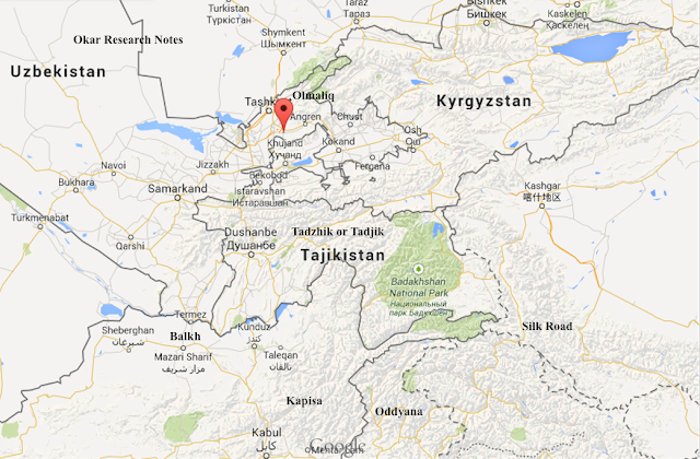
Click on the map to enlarge

"Tajik, also spelled Tadzhik, sometimes called (before the 20th century) Sart, the original Persian-speaking population of Afghanistan and Turkistan. The Tajiks constitute almost four-fifths of the population of Tajikistan. In the early 21st century there were more than 5,200,000 Tajiks in Tajikistan and more than 1,000,000 in Uzbekistan. There were about 5,000,000 in Afghanistan, where they constituted about one-fifth of the population. Another 40,000 lived in the Uygur Autonomous Region of Xinjiang in China......The name Tajik refers to the traditionally sedentary people who speak a form of Persian called Tajik in Tajikistan and Uzbekistan and who speak the modern Persian language in Afghanistan."

Click on the map to enlarge

"Tagzig Olmo Lung Ring is a non-dual spiritual realm (plane or dimension) of the Bon tradition which resides beyond dualism. It is understood to be a timeless perfected realm where peace and joy are the very fabric of being. This country-name rTa-gzig is believed to be a form of the name Tajik; while the Ol-mo-lung-ring is believed to be a form of the name of the city Olmaliq (now reckoned as being within Uzbekistan, but formerly included within Tajikistan)."

"The Tajiks were the heirs and transmitters of the Central Asian sedentary culture that diffused in prehistoric times from the Iranian plateau into an area extending roughly from the Caspian Sea to the borders of China. They built villages of flat-roofed mud or stone houses and cultivated irrigated fields of wheat, barley, and millet. Their gardens were famous for melons and a variety of fruits. Their crafts were highly developed, and their towns along the caravan routes linking Persia, China, and India were centres of trade. Turks subsequently migrated westward into the area inhabited by the Tajiks. The latter became Turkicized in their culture, though many retained their Iranian language......http://www.britannica.com/EBchecked/topic/581024/Tajik

"Mount Garmo (Tajik: Қуллаи Гармо, Qullai Garmo, Russian: пик Гармо, pik Garmo) is a mountain of the Pamirs in Tajikistan, Central Asia, with a height reported to be between 6,595 metres and 6,602 metres....Formerly in the Soviet Union, Garmo forms part of the Akademiya Nauk Range....A Russian expedition to the region in 1928 made the first ascent of Lenin Peak and also measured the height of what is now officially called Ismoil Somoni Peak, which may have been mistakenly identified with Garmo although it lies some sixteen kilometres to the north of the present Garmo."

"The Beyul realm of Tagzig Olmo Lung Ring is fabled to be located to the west of Mount Kailash and shaped like an eight-petaled lotus and divided into four regions: inner, middle, outer and boundary area. The sky of this realm is likened to an eight-spoked wheel (refer Dharmachakra) and the land itself is fragrant and coloured by beautiful flora and landscaping, chorten and snow-capped mountains.......Central to Tagzig Olmo Lung Ring is Yungdrung Gutsek, a pyramidal-shaped mountain serving as axis mundi with nine Yungdrungs....(sauwastika) ascending like a staircase evocative of the Nine Ways (or stages) of Bon. The four faces of the pyramidal mountain, face the four cardinal directions. At the corner-joints of Yungdrung Gutsek (cross-quarter directions) four rivers flow from simulacra of archetypal thoughtforms:
from the simulacrum of a snowlion the river Narazara flows from the East;
from the simulacrum of a horse the river Pakshi flows from the North;
from the simulacrum of a peacock the river Gyim Shang flows from the West; and
from the simulacrum of an elephant the river Sindhu flows from the South.
...Geshe Nyima Dakpa Rinpoche (2006). Opening the Door to Bon. Snow Lion Publications.

"Olmaliq also spelled as Almalyk (Uzbek: Olmaliq / Олмалиқ; Russian: Алмалык) is a city (2004 pop est 138,000) in the Tashkent Province of central Uzbekistan, approximately 65 km east of Tashkent. It is located at latitude 40° 50' 41N; longitude 69° 35' 54E; at an altitude of 585 meters.

"Tajik (Persian: تاجيك‎, also Romanized as Tājīk) is a village in Jeyransu Rural District, in the Central District of Maneh and Samalqan County, North Khorasan Province, Iran....Khorasan (Persian: استان خراسان‎ ).... (also transcribed as Khurasan and Khorassan, also called Traxiane during Hellenistic and Parthian times) was a province in north eastern Iran, but historically referred to a much larger area east and north-east of the Persian Empire. The name Khorasan is Persian and means "where the sun arrives from." The name was given to the eastern province of Persia during the Sassanid Empire."...The older Persian province of Khorasan included parts which are today in Iran, Afghanistan, Tajikistan, Turkmenistan and Uzbekistan. Some of the main historical cities of Persia are located in the older Khorasan: Nishapur and Tus (now in Iran), Merv and Sanjan (now in Turkmenistan), Samarkand and Bukhara (both now in Uzbekistan), Herat and Balkh (now in Afghanistan), Khujand and Panjakent (now in Tajikistan). In its long history, Khorasan knew many conquerors and empires: Greeks, Mauryans, Arabs, Seljuk Turks, Safavids, Baloch, Pashtuns and others."

"The influence of the Buddhist art of Fondukistan, dated to the seventh and eighth centuries, is reflected in the contemporaneous art of northern Toḵārestān, exemplified by the murals and clay sculpture from the Buddhist monastery at Adzhina tepe, near Kurgan Tyube, in southern Tajikistan. The colossal image of a recumbent Buddha (originally 12 m) from this site, recalls the gigantic Buddha image of Bāmīān, noted by the Chinese pilgrim Hsüan tsang in the seventh century, and other large Buddha images uncovered in western Turkestan (from Krasnaya rechka near Frunze, Kuva in Ferghana [Farḡāna], and Marv).."....http://www.iranicaonline.org/articles/art-in-iran-vi-pre-islamic-eastern-iran-and-central-asia

Click on the map to enlarge

The road from Ghazni to the valley of Band-e Amir and Yakaulang. (© Minoru Inaba).....http://pro.geo.univie.ac.at/projects/khm/showcases/showcase12?language=en

"FONDOQESTĀN......(FONDUKISTAN), early medieval settlement and Buddhist monastery in Afghanistan, in the province of Parvān (Parwan). The site is usually dated to the 7th century CE on the evidence of artistic style and numismatic finds, the oldest of which is from 689 C.E. However, the shape and the decorations of the stupa suggest that the complex can be even earlier. The site is situated in the Ḡūrband valley, five kilometers south of Sīāhgerd and 117 kilometers north-east of Kabul, at 34° 58′ N 68° 53′ E. It was named after a village located nearby....Unfortunately, no detailed description or documentation of the site has ever been published. The most important data about the installations is still unavailable; even the exact size of the structures is not known.".....http://www.iranicaonline.org/articles/fondoqestan-

"Adzhina Tepe - a hill located 12 km from the Tajik city of Kurgan-Tube.... the Buddhist sites further east at Adzhina Tepe near Kurgan-Tyube, at Kuva in Farghana and at Ak-Beshim near Frunze...Splendid Buddhist remains of the 7th-8th century A.D. have been dug up since 1959 in Adzhina-tepe (the "Devil's Mound", 12 km off Kurgan-Tyube) by Litvinskiy....The architecture and decoration of the monastery organically merged local traditions and ancient Tokharistan various Indian elements. International Organization UNESCO awarded Adzhina Tepe nominee status as a UNESCO World Heritage Site."

Click on the map to enlarge

"The Vakhsh River (Tajik: Вахш), also known as the Surkhob (in north-central Tajikistan) and the Kyzyl-Suu (in Kyrgyzstan), is a Central Asian river, and one of the main rivers of the nation of Tajikistan. It is a tributary of the Amu Darya (Oxus) river.....Intensive agriculture in the Vakhsh basin has left the river polluted with fertilizers, pesticides, and salts...Since the waters of the Vakhsh eventually flow into the Aral Sea, pollution in the Vakhsh contributes to eutrophication there....The Vakhsh is fed by the glaciers of the Pamirs, one of the world’s most susceptible regions to climate change. "

**************************

Email....okarresearch@gmail.com

April 2015

John Hopkins....Northern New Mexico

**************************

Monday, March 16, 2015

Koykrylgan Kala...Qoy Qirilq'an Qala...4th c. BC

**************************

Click Here to View the Main Index

**************************

"Khwarezm /kwəˈrɛzəm/ or Chorasmia /kəˈræzmiə/ (Persian: خوارزم‎) is a large oasis region on the Amu Darya river delta in western Central Asia.....C.E. Bosworth however, believes the Persian name to be made up of xor (خور "the sun") and zam (زم "earth, land"), designating "the land from which the sun rises", although the same etymology is also given for Khurasan. ".....C. E. Bosworth, The Encyclopedia of Islam, Vol IV, 1978. p. 1061

Aerial view of Koykrylgan Kala...."Koykrylgan Kala (also spelt Qoy Qirilq'an Qala) is an amazing and enigmatic site. Its circular shape is unique. Koykrylgan Kala is a 4th century BC fortress, but what lay within the fortifications is a mystery. Today, the site lies in a remote part of the surrounding desert. In the 2nd century BC, the complex was destroyed by fire, was rebuilt and remained in use until the 4th century AD. "...http://www.heritageinstitute.com/zoroastrianism/khvarizem/page4.htm

"Koy-Krylgan-kala: the Fortress of Lost Rams....Ruins of thousands of fortresses are disseminated at boundless open spaces of the Khorezm steppes, but the remnants of Koy-Krylgan-kala, the Fortress of Lost Rams, are unique. The fortress was discovered by archeologists of the Khorezm expedition casually in 1938. Archeologists were surprised with the form of ancient construction, unprecedented till then in Khoresm: the powerful citadel with the remains of a protective wall was not square and or rectangular as it was used to see, but it was round. Outside, protective constructions had the form of a correct circle with the citadel in the center, it was surrounded with an external fortification with towers. The space between the central building and the wall named the "ring" appeared completely built up. The clay construction was enormous: diameter of the central building was 42 m, height in the best remained part was about 8 m, the diameter of the whole construction - about 90 m......Thousands of fragments of magnificent pottery have been scattered on sandy barkhans round the fortress and among its ruins. Along with other findings, in particular bronze tips of arrows, they were used to identify its age - archeologists found out that it was the most ancient of all the monuments to ancient Khorezmian statehood known by that time. The earliest finds dated back to 4th-3rd centuries BC.... the fortress had two stages of the development. Earlier stage dated back to 4th-3rd centuries BC. The second period of the fortress referred to the first centuries AD."....http://www.advantour.com/uzbekistan/karakalpakstan/koy-krylgan-kala.htm

"Qoy Qırılg'an qala is in a remote desert location, just over 24km north northeast of To'rtku'l and 20km east southeast from Bostan. It lies within the tuman of To'rtku'l. ....The first archaeological viewing took place in 1938 when Sergey Tolstov, Yakh'ya Gulyamov, A. I. Terenozhkin and other members of the early Khorezm Archaeological Expedition were encamped at nearby Teshik qala...its 5 to 6 metre high walls were covered with narrow closely spaced loopholes. It was surrounded by a circular wall reinforced by the ruins of nine towers. The interior was filled with fragments of glazed and richly decorated ceramics and Tolstov found bronze Scythian arrow heads and two terracotta statuettes. Qoy Qırılg'an qala is a name that has been given to the site by local people over recent centuries. It is generally translated as "Fort of the Dead Sheep". However the exact meaning of Qırılg'an is not dead but fragile or breakable...Today only the central part of the fort remains. It is in a badly eroded state. Soviet archaeologists tended to leave their completed excavations exposed to the elements, and these mud-brick monuments are easily damaged by the winter rains. To make matters worse much of the mud brick from the outer walls seems to have been taken and recycled by local people.."....David and Sue Richardson 2005 - 2015.....http://www.karakalpak.com/anckoy.html

"Koy-Krylgan-kala was the powerful well fortified fortress with a number of protective walls which were destroyed with time, it was possible to trace them only in a small site. Similar fortifications were peculiar to all monuments of antiquity and the early Middle Ages of Khoresm. According to researches of archeologists, the Fortress of Lost Rams is one of the most ancient monuments ancient Khorezm statehood, the temple complex that partially functioned as a burial of the unknown ancient king or queen.......The fortress population consisted of Zoroastrians, worshipping Anakhita, the goddess of water and rivers, and Siyavus, the god of sun. This monument is interesting in terms of the central complex location. Its western part was built in honour of the goddess Anakhita, and eastern and the southern parts were turned towards the sun rising in honour of the god of sun Siyavush, evidenced by number of figurines and relicts of vessels with images of gods......The fortress history Koy-Krylgan-kala totals a millenium. The remnants of the most ancient ossuaries in the Central Asia were found along with paintings and inscriptions in ancient Khorezmian language. This fortress remains a historical puzzle until now, standing out with its unique design among other fortresses of Ancient Khorezm.".....http://www.advantour.com/uzbekistan/karakalpakstan/koy-krylgan-kala.htm

"Qoy Qırılg'an qala......Even today, the true purpose of the site still remains something of a mystery. Excavations showed that the building had been destroyed by fire and had later been ransacked. It seems to have originally been built in the 4th century BC shortly after Khorezm gained its independence from Persia. This period, originally named after the Kangyuy culture of the middle Syr Darya and now called the Early Antique Period, saw a huge blossoming of Khorezmian culture. Yet surprisingly the building was used for only one or at most two centuries before being abandoned in the early 2nd century BC. It was then briefly occupied by squatters.....It is possible that the lower floor might have originally functioned as some type of astronomical observatory, possibly monitoring the times for the rising and setting of certain stars and perhaps the cycles of the sun and the moon, given their highly venerated position in Zoroastrianism. We do know that the Khorezmians were familiar with eclipses, had an accurate calendar and knew the exact time of the seasons – vital for the management of their agricultural economy."...David and Sue Richardson 2005 - 2015....http://www.karakalpak.com/anckoy.html

"Siyawush......Persian - Son of Kay Kaus and Sudabe. His stepmother made advances which he rejected and she told her husband that his son had tried to rape her. The young man fled from the court but was killed by Afrasiyab. Sometimes referred to as Siyawush, Siyavahsh, Siyavahsh, Siyavarshan, Siyavarshan, Syavarsham or Syavarsham.....Siyâvash ( Persian (Persian) : سياوش) is a character in Shahnameh of Ferdowsi . One of the prince of Iran . He was executed by the orders of afrasyab .".....http://www.mythologydictionary.com/siyawush-mythology.html

"Kay Kāvus (Persian: كيكاوس‎; Avestan: Kauui Usan); sometimes Kai-Káús or Kai-Kaus, is a mythological shah of Iran and a character in the Shāhnāmeh. He is the son of Kay Qobād and the father of prince Seyāvash. Kāvus rules Iran for one hundred and fifty years during which he is frequently though increasingly grudgingly aided by the famous hero Rostam. He is succeeded by his grandson Kai Khosrow."....Firdawsī, The Sháh námeh of the Persian poet Firdausí. Oriental Translation Fund. Volume 21 of Publications, Oriental Translation Fund. Translated by James Atkinson. 1832.

"......Betts, A.V.G. and Yagodin, V.N. 2007 The Fire Temple at Tash-k’irman-tepe, Chorasmia.....http://www.academia.edu/3580384/Betts_A.V.G._and_Yagodin_V.N._2007_The_Fire_Temple_at_Tash-k_irman-tepe_Chorasmia "

"Historians mention that one of the names for the Oxus or Amu in ancient Afghanistan was Gozan, and that this name was used by Greek, Mongol, Chinese, Persian, Jewish, and Afghan historians. However, this name is no longer used.
"Hara (Bokhara) and to the river of Gozan (that is to say, the Amu, (called by Europeans the Oxus)...."....The Kingdom of Afghanistan: a historical sketch, By George Passman Tate
"the Gozan River is the River Balkh, i.e. the Oxus or the Amu Darya....."....Jews in Islamic countries in the Middle Ages, By Moshe Gil, David Strassler
"... and were brought into Halah (modern day Balkh), and Habor (which is Pesh Habor or Peshawar), and Hara (which is Herat), and to the river Gozan (which is the Ammoo, also called Jehoon)...".....Tamerlane and the Jews, By Michael Shterenshis

**************************

Email....okarresearch@gmail.com

March 2015

John Hopkins....Northern New Mexico

**************************

Sunday, March 15, 2015

The Kala (Fortress/Castles) of Ancient Khorasan (500 BC)

**************************

Click Here to View the Main Index

**************************

The name "Khorasan" is derived from Middle Persian khor (meaning "sun") and asan (or ayan literally meaning "to come" or "coming" or "about to come"), hence meaning "land where the sun rises".

"Forgotten realms of the Oxus region.....Ruins of thousands of fortresses (Kala) are disseminated at boundless open spaces of the Khorezm steppes.......The ancient cities and fortresses along the Oxus and nearby rivers........It's unknown exactly where antiquity-era Chorsamia was centred, although part of the ruins of Kyrk Molla at Gurganj date back to this period, as do part of the ruins of Itchan Kala in present-day Khiva (Khwarezm's capital). Probably the most impressive and best-preserved ancient ruins in the region, are those of the Ayaz Kala fortress complex, parts of which date back to the 4th century BC. There are numerous other "Kala" (the Chorasmian word for "fortress") nearby, including Toprak Kala and Kz'il Kala. "....http://greenash.net.au/thoughts/2014/10/forgotten-realms-of-the-oxus-region/

Ayaz Kala (fortress 2) of Khwarezm (Chorasmia), today desert but in ancient times green and lush....http://greenash.net.au/thoughts/2014/10/forgotten-realms-of-the-oxus-region/

"In classical antiquity, a number of advanced civilisations flourished in the area that today comprises parts of Turkmenistan, Uzbekistan, Tajikistan, and Afghanistan. Through this area runs a river most commonly known by its Persian name, as the Amu Darya. However, in antiquity it was known by its Greek name, as the Oxus....The Oxus region is home to archaeological relics of grand civilisations, most notably of ancient Bactria, but also of Chorasmia, Sogdiana, Margiana, and Hyrcania. However, most of these ruined sites enjoy far less fame, and are far less well-studied, than comparable relics in other parts of the world......most of the ruins have been neglected by the modern world – largely due to the region's turbulent history of late....."...http://greenash.net.au/thoughts/2014/10/forgotten-realms-of-the-oxus-region/

Overview map of the Oxus region, showing major rivers and antiquity-era archaeological sites..... Forgotten realms of the Oxus region......http://greenash.net.au/thoughts/2014/10/forgotten-realms-of-the-oxus-region/

"The Oxus is the largest river (by water volume) in Central Asia. Due to various geographical factors, it's also changed its course more times (and more dramatically) than any other river in the region, and perhaps in the world."

Faizabad Kala....(Fayzabad, Feyzabad, Fazelabad or Faizabad) (Pashto:فيض آباد), Persian: فيض آباد‎) is the provincial capital and largest city in Badakhshan Province, in northern Afghanistan, with around 50,000 people. It is situated in Fayzabad District and is at an altitude of 1,200 m. (3,937 ft.)....It is located in the northeast of Afghanistan, on the River Kokcha. It is the main commercial and administrative center of the Pamir region."

Kaakha fortress, overlooking the Panj river.....(Hava Afghanistan). ....The second fortress intended for protection of the Western Pamir is called Kaakha after a legendary warrior, the king of fire - worshippers. It was constructed later, in the 4th century, on a rocky height in the Panj valley. It seems that the fortress borders the rock with its mud brick wall. Only the sagged clay rampart from the second inner wall has remained. The fortress design is similar to that of Yuachmun: with a citadel and three platforms. The length of the rampart is really impressive - 750 m (!). No buildings were found inside the fortress. Probably the rooms were only in the citadel.The alleged purpose of the fortress was as follows: due to its powerful walls it prevented the invaders, who could come through the valleys of the rivers Panj, Shakhdara and Gunt, from getting to the fertile oases. Today the remains of the fortifications can be seen directly from the highway which passes 15-20 meters from the fortress. In spite of the fact that the fortress it badly damaged you can clearly imagine what a powerful structure with numerous towers it was, how impregnable and formidable it seemed in ancient times...http://www.advantour.com/tajikistan/mountains/pamir/kaakha-fortress.htm......Kaakha Fortress, Pamir.....http://greenash.net.au/thoughts/2014/10/forgotten-realms-of-the-oxus-region/

Igdy Kala.......Igdy Kala is a Parthian fortress dated I century B.C. - IV century A.D. located on the high rocky bank of Uzboy river, creating a narrow and picturesque canyon. It’s situated in 150 km to North from Serdar city........Settlements along the lower Uzboy part of Hyrcania (which was on occasion given a name of its own, Nesaia) were few. The most notable surviving ruin there is the Igdy Kala fortress, which dates to approximately the 4th century BC, and which (arguably) exhibits both Parthian and Chorasmian influence. Very little is known about Igdy Kala, as the site has seldom been formally studied. The question of whether the full length of the Uzboy ever existed remains unresolved, particularly regarding the section from Sarykamysh Lake to Igdy Kala. ... S.P.Tolstov discovered this monument in 1954....in whole the fortress constructed from stone which is non-typical material for Khorezm....http://www.dagtravel.net/en/sightseeing-list/balkan/igdy-kala/

Aerial view of Koykrylgan Kala....Koykrylgan Kala (also spelt Qoy Qirilq'an Qala) is an amazing and enigmatic site. Its circular shape is unique. Koykrylgan Kala is a 4th century BC fortress, but what lay within the fortifications is a mystery. Today, the site lies in a remote part of the surrounding desert. In the 2nd century BC, the complex was destroyed by fire, was rebuilt and remained in use until the 4th century AD. "...http://www.heritageinstitute.com/zoroastrianism/khvarizem/page4.htm

Koy-Krylgan-kala: the Fortress of Lost Rams....Ruins of thousands of fortresses are disseminated at boundless open spaces of the Khorezm steppes, but the remnants of Koy-Krylgan-kala, the Fortress of Lost Rams, are unique. The fortress was discovered by archeologists of the Khorezm expedition casually in 1938. Archeologists were surprised with the form of ancient construction, unprecedented till then in Khoresm: the powerful citadel with the remains of a protective wall was not square and or rectangular as it was used to see, but it was round. Outside, protective constructions had the form of a correct circle with the citadel in the center, it was surrounded with an external fortification with towers. The space between the central building and the wall named the "ring" appeared completely built up. The clay construction was enormous: diameter of the central building was 42 m, height in the best remained part was about 8 m, the diameter of the whole construction - about 90 m......Thousands of fragments of magnificent pottery have been scattered on sandy barkhans round the fortress and among its ruins. Along with other findings, in particular bronze tips of arrows, they were used to identify its age - archeologists found out that it was the most ancient of all the monuments to ancient Khorezmian statehood known by that time. The earliest finds dated back to 4th-3rd centuries BC.... the fortress had two stages of the development. Earlier stage dated back to 4th-3rd centuries BC. The second period of the fortress referred to the first centuries AD."....http://www.advantour.com/uzbekistan/karakalpakstan/koy-krylgan-kala.htm

"Koy-Krylgan-kala was the powerful well fortified fortress with a number of protective walls which were destroyed with time, it was possible to trace them only in a small site. Similar fortifications were peculiar to all monuments of antiquity and the early Middle Ages of Khoresm. According to researches of archeologists, the Fortress of Lost Rams is one of the most ancient monuments ancient Khorezm statehood, the temple complex that partially functioned as a burial of the unknown ancient king or queen.......The fortress population consisted of Zoroastrians, worshipping Anakhita, the goddess of water and rivers, and Siyavus, the god of sun. This monument is interesting in terms of the central complex location. Its western part was built in honour of the goddess Anakhita, and eastern and the southern parts were turned towards the sun rising in honour of the god of sun Siyavush, evidenced by number of figurines and relicts of vessels with images of gods......The fortress history Koy-Krylgan-kala totals a millenium. The remnants of the most ancient ossuaries in the Central Asia were found along with paintings and inscriptions in ancient Khorezmian language. This fortress remains a historical puzzle until now, standing out with its unique design among other fortresses of Ancient Khorezm.".....http://www.advantour.com/uzbekistan/karakalpakstan/koy-krylgan-kala.htm

Khairizem / Khvarizem/ Chorasmia Historical Sites...http://www.heritageinstitute.com/zoroastrianism/khvarizem

**************************

Email....okarresearch@gmail.com

March 2015

John Hopkins....Northern New Mexico

**************************